The route network for Western Europe and the Danube have been added to WinGPS Marine, Stentecs navigation app for Android devices. The route network gives you the possibility to make complete routes over the inland waters while only having to place a start and end point. Taken into account are the measurements of your ship, measurements for bridges and lock (height, width) and of course the waterway information (depth, width).
Route network
Before the update it was only possible to create waypoints with a straight line between them. This wouln't be a problem when planning a route on open water. But planning a route on inland waters, with a lot of curvy channels and rivers, would become very tedious with a lot of waypoints.
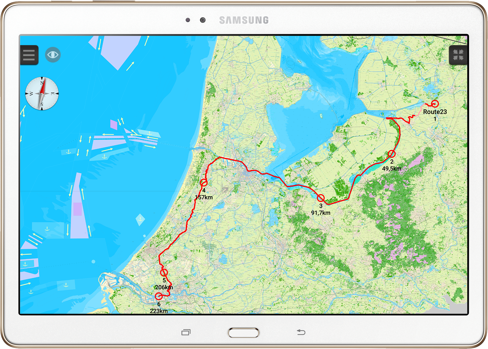
With the new update you will only have to set two waypoints for a complete route: one on your starting position and one for your destination. Make sure both waypoints are placed upon the route network. WinGPS Marine will plot the shortest route from start to finish across the water ways.
Click on the image for a larger view.
Click on the image for a larger view.
If a bridge or lock can't be passed due to size limitations this will be marked by a dotted circle. If the plotted route runs along a water way which is too shallow that part will be shown in a different color. Both options make it possible to foresee blocks along the route giving you the option to plot your route along another water way.
Click on the image for a larger view.
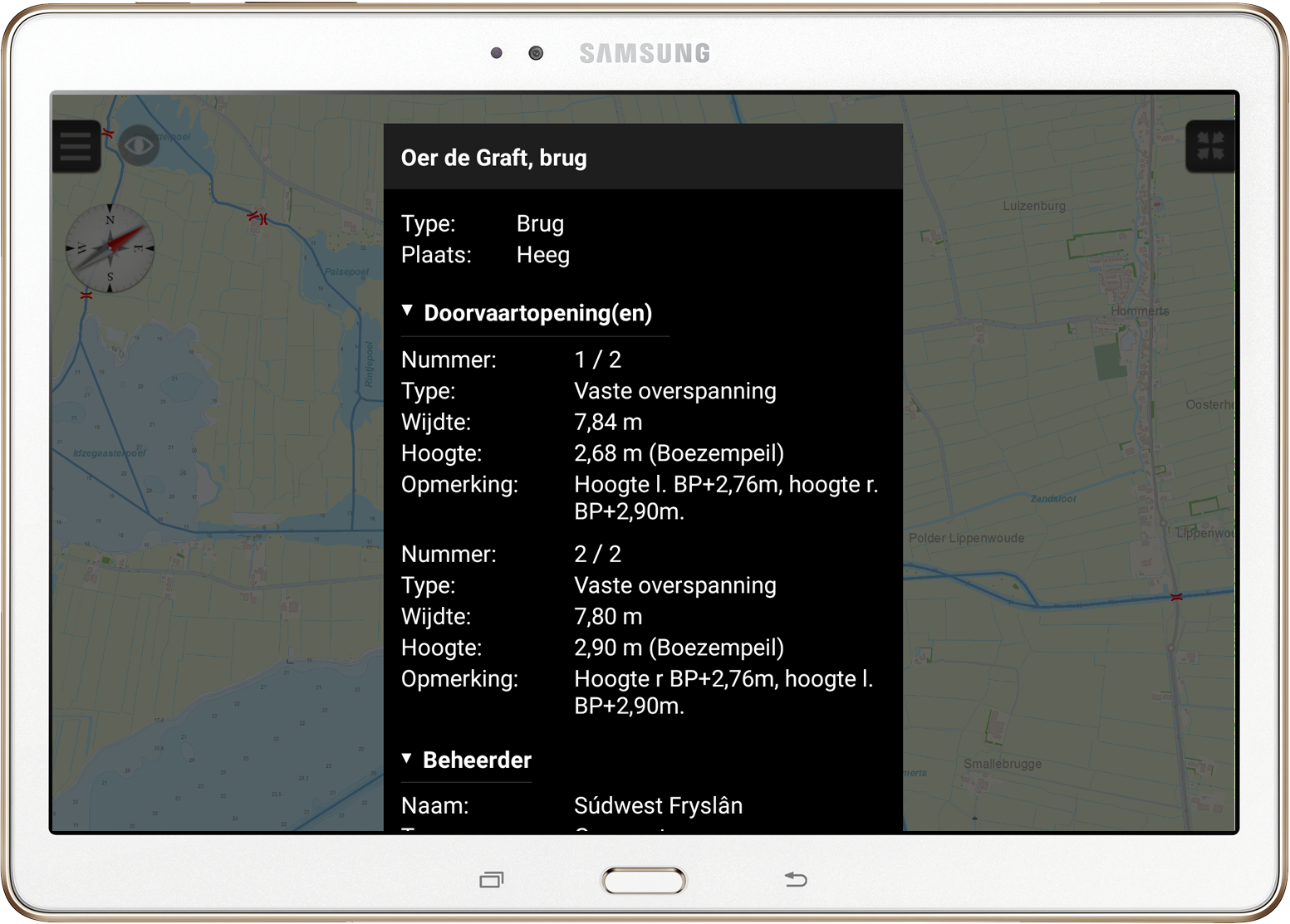
When you double click on a bridge, lock or water way a new window will appear with all known information (See image below). For example, the telephone number for the bridge operator, passage times or number of passage ways.
Tips:
Go to 'Menu - Settings - General'. Set your 'Units in the app' to 'Inland' to see distances in km's and speed in km/hr.
Go to 'Menu - Settings - Your ship'. Set the diameters of your ship. This information is used when plotting new routes.
Go to 'Menu - Settings - Routes'. Choose your preferences.
Go to 'Menu - Settings - Route Network'. When you are not going to use the Route network, for example when sailing on open sea. you can disable it here. At the bottom of the page individual parts of the Route network can be enabled/disabled. The only visible parts will correspond with the charts you have installed on your system. The less parts of the Route network you have enabled, the faster the app wil work.
A new route can be made by pressing the charts and holding for a few seconds. A new window will appear. Choose 'create new route'. The first waypoint will be placed on the exact place you clicked. Move the point to the correct position and place the remaining waypoints.
During the placement of a waypoint it can be moved by selecting it and sliding it across the screen with your finger. The color of the waypoint will change when moving: when it turns red while moving it is not properly placed on the Route network. Place it closer towards the Route network until it turns grey. Let go of the waypoint. It will be locked on the Route network.
A pink route line means your ship can not pass this water way due to depth issues. A red route line means there are no depth issues. Add a waypoint at this point and drag it to another part of the Route network to navigate past the shallow water way.
Go to 'Menu - Route manager'. All your routes will be stored here. We recommend you only enable the route you want to sail, by setting a tick before the route. All other routes can be disabled by removing the tick in front of them. Enabling more, if not all routes will slow down your system.
Follow this link for a full 'Frequently Asked Questions' list.
Please mind: when plotting a route the speed of your ship and bridge/lock operating time are not accounted for within WinGPS Marine. It is advisable to only use the route function for short routes in the nearby future. Ideally while planning a one day trip right before setting sail.
With the Windows version of WinGPS on your laptop you can plan larger routes in which speeds and operating times are accounted for. For example, very useful when plotting a route along the Rhine-Moselle-Maas or to Berlin.
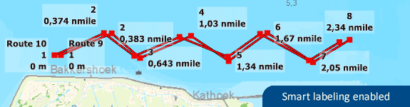
Update - Smart labeling
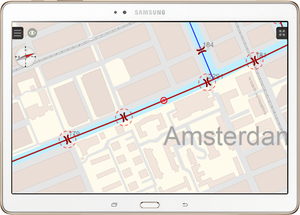
The inland water charts are so called 'hybrid charts'. This means the chart itself is a rasterized image, with several overlays for different waypoint sets. These waypoint sets consist of buoys, harbours, moorings, bridges, locks etc. Attached to a waypoint is a text label with information regarding this specific waypoint such as the name of the buoy or harbour. When a lot of waypoints are close together all text labels would overlap, which made them unreadable.
To counteract this problem the 'smart labeling' option is introduced. Instead of overlapping text labels this option places all text labels at different locations around each waypoint while not overlapping one another (see image below). When too much labels are visible at one place, some labels will be disabled for that specific zoom scale. When zooming in further, more text labels will become visible. The 'smart labeling' options provides a much clearer chart view.
Tip: Via the 'show on chart' setting (eye button on the top left) the Smart labeling option can be enabled/disabled. If you want all text labels to be disabled this can be done at the same options by clearing the tick by 'Waypoint names'. Double clicking on a specific waypoint will show all informaton in a new screen.
Getting started
Download WinGPS Marine Lite on your Android tablet or smartphone.
Upgrade to WinGPS Marine Plus to make use of the full potential of your device.